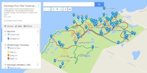
My cellphone is attached to my hip – almost surgically :). On this cellphone I’m forever using Google maps. It’s a great feature with its road layout layer and satellite layer, however, at times I need it to locate to specific POIs (points of interest) or trails, etc.
I have found a way of creating custom Google map layers with the help of QGIS software, a bunch of file formats and map resources (satellite images, paper maps and Open Street Maps) I have an example of this on this link.
Now I’m willing to be that ‘mobile map layer creator guy’ for whatever purpose you may have for a more customized map layer on top of that easily accessible Google map app. Possibilities include art studio tour POIs, Park maps, real estate locations, additional tourist info. ….. Contact us with your layer idea.


